


VTD - precinct 3, Jackson County, South Dakota
About
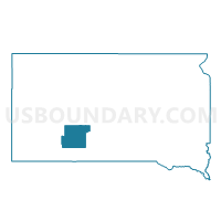
Outline

Summary
| Unique Area Identifier | 667402 |
| Name | VTD - precinct 3 |
| County | Jackson County |
| State | South Dakota |
| Area (square miles) | 481.39 |
| Land Area (square miles) | 478.36 |
| Water Area (square miles) | 3.03 |
| % of Land Area | 99.37 |
| % of Water Area | 0.63 |
| Latitude of the Internal Point | 43.77746610 |
| Longtitude of the Internal Point | -101.52582970 |
Maps


Graphs
Select a template below for downloading or customizing gragh for VTD - precinct 3, Jackson County, South Dakota


Neighbors
Neighoring Voting District (by Name) Neighboring Voting District on the Map
- VTD - 7, Jackson County, SD
- VTD - Cottonwood voting precinct, Jackson County, SD
- VTD - Interior voting precinct, Jackson County, SD
- VTD - Kadoka City Ward 1 voting precinct (part of VTD-4), Jackson County, SD
- VTD - Kadoka City Ward 2 voting precinct (part of VTD-4), Jackson County, SD
- VTD - Kadoka City Ward 3 voting precinct, Jackson County, SD
- VTD - Long Valley precinct, Jackson County, SD
- VTD - precinct 20, Haakon County, SD
- VTD - precinct 5, Jackson County, SD
- VTD-precinct 19, Haakon County, SD
- VTD-precinct 6, Mellette County, SD
Top 10 Neighboring County Subdivision (by Population) Neighboring County Subdivision on the Map
- Southwest Jackson UT, Jackson County, SD (1,626)
- Kadoka city, Jackson County, SD (654)
- West Haakon UT, Haakon County, SD (583)
- East Haakon UT, Haakon County, SD (446)
- Cedarbutte UT, Mellette County, SD (209)
- Northeast Jackson UT, Jackson County, SD (206)
- Southeast Jackson UT, Jackson County, SD (187)
- Northwest Jackson UT, Jackson County, SD (95)
- Wall township, Jackson County, SD (39)
- Jewett township, Jackson County, SD (14)
Top 10 Neighboring Place (by Population) Neighboring Place on the Map
Top 10 Neighboring Unified School District (by Population) Neighboring Unified School District on the Map
- Kadoka School District 35-2, SD (3,298)
- White River School District 47-1, SD (1,782)
- Haakon School District 27-1, SD (1,697)
Top 10 Neighboring State Legislative District Lower Chamber (by Population) Neighboring State Legislative District Lower Chamber on the Map
Top 10 Neighboring State Legislative District Upper Chamber (by Population) Neighboring State Legislative District Upper Chamber on the Map
Top 10 Neighboring 111th Congressional District (by Population) Neighboring 111th Congressional District on the Map
Top 10 Neighboring Census Tract (by Population) Neighboring Census Tract on the Map
- Census Tract 9403, Mellette County, SD (2,048)
- Census Tract 9601, Haakon County, SD (1,937)
- Census Tract 9412, Jackson County, SD (1,813)
- Census Tract 9611, Jackson County, SD (1,218)
Top 10 Neighboring 5-Digit ZIP Code Tabulation Area (by Population) Neighboring 5-Digit ZIP Code Tabulation Area on the Map
- 57567, SD (1,406)
- 57577, SD (1,211)
- 57543, SD (870)
- 57560, SD (436)
- 57750, SD (295)
- 57521, SD (167)
- 57547, SD (139)